
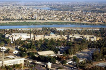
Iraq is situated in what was known as ancient Mesopotamia (the land between two rivers, Dijla and Euphrates). It occupies the eastern wing of the Fertile Crescent, a relatively fertile area of land in an otherwise arid region. Iraq is located in the Middle East and North Africa region and shares borders with Turkey to the north, Iran to the east, Syria and Jordan to the west, and Saudi Arabia and Kuwait to the south. Iraq's location is significant, as it is one of the easternmost countries of the Arab world and sits on the same latitude as the southern United States. Iraq can be divided into four geographical regions. The Tigris-Euphrates alluvial plains in central and southeastern Iraq, Al-Jazeerah, an upland area in northwestern Iraq between the Tigris and Euphrates rivers, deserts in the west and south, covering about two-fifths of the country, and highlands in the north and northeast. The Tigris-Euphrates River system drains into Iraq, fed by melting winter snow in Turkey and Iran, which gives Iraq viable soil to support agriculture, a significant component of the economy.
Urban and Rural Settlement
Iraq is situated in what was known as ancient Mesopotamia (the land between two rivers, Dijla and Euphrates). It occupies the eastern wing of the Fertile Crescent, a relatively fertile area of land in an otherwise arid region. Iraq is located in the Middle East and North Africa region and shares borders with Turkey to the north, Iran to the east, Syria and Jordan to the west, and Saudi Arabia and Kuwait to the south. Iraq's location is significant, as it is one of the easternmost countries of the Arab world and sits on the same latitude as the southern United States. Iraq can be divided into four geographical regions. The Tigris-Euphrates alluvial plains in central and southeastern Iraq, Al-Jazeerah, an upland area in northwestern Iraq between the Tigris and Euphrates rivers, deserts in the west and south, covering about two-fifths of the country, and highlands in the north and northeast. The Tigris-Euphrates River system drains into Iraq, fed by melting winter snow in Turkey and Iran, which gives Iraq viable soil to support agriculture, a significant component of the economy.
Facts about Iraq’s Geography
- Iraq has the fifth largest proven reserves of petroleum in the world.
- Iraq has substantial reserves of natural gas.
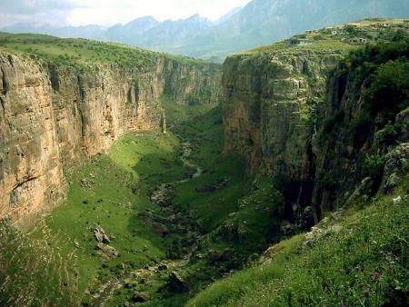
- The mountains, hills, and plains of north and northeastern Iraq occupy about 35,500 square miles (92,000 square kilometers), about one-fifth of the country.
- Dams play an essential role in controlling flooding and permitting irrigation, and Iraq has many giant irrigation projects.
- The total area of Iraq is 437,072 square kilometers: about the size of California.
- Cities: Capital–Baghdad (7.2 million, 2006 estimate). Other cities–Basra, Mosul, Najaf, Karbala, Erbil, and Kirkuk.
- In accordance with the statistics of 2006, Iraq is administratively divided into (18) governorates. About 7.2 million people inhabit the capital Baghdad. The governorates are divided into (120) districts, and each is divided into several sub-districts. Anbar Governorate is the largest governorate in Iraq by area.
- Iraq's terrain consists mainly of alluvial plains, mountains, and deserts.
- The climate of Iraq is primarily hot and dry.
Climate and Soil
Iraq's average temperature is 70 °F (21°C), and the average monthly rainfall is less than an inch (16 mm), depending on the season. There are two seasons, summer, and winter, with only short transitional periods between the two. Summer lasts from May to October and is characterized by cloudless skies, hot temperatures, low humidity, and no precipitation from June through September. Temperatures in Baghdad average 95 °F (35 °C) but have been recorded up to 123 °F (51 °C) during summers. During the winter, which lasts from December to February, temperatures are mild, with bouts of hot and cold ranging between 35 and 60 °F (2 to 15 °C). Rainfall averages just over an inch per month (29 mm) between November and April.
Iraq has two climatic provinces: The lowlands, including the alluvial plains, and the hot and arid deserts. The damper northeastern region is known for its higher elevation and mountain ranges, which produce cooler temperatures in winter and relatively moderate temperatures in summer. Heavy alluvial soils cover the lowlands with a high proportion of clay suitable for cultivation and building materials. In the northeast, summer is shorter, while winter lasts longer. The more significant winter rainfall sustains good seasonal pastures.
The steady, northerly, and northwesterly wind is common to Iraq, bringing dry air and a cloudless sky. Additionally, a southern and southeast wind brings dust storms throughout the year, but most frequently in the summer.
Plant and Animal Life
The country's arid climate and harsh terrain greatly influence plant and animal life in Iraq. Vegetation in Iraq is characterized by drought, and forests are scarce except for small oak forests in the north and northeast. Alpine plants grow in the cool, dry climate of the mountains, while shrubs and herbs thrive in more arid regions. Grasses and lush plants can be found along the Tigris and Euphrates rivers.
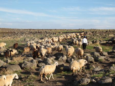
Wildlife is also adapted to harsh environments. The most common animals are birds, such as ducks, partridges, snipes, and herons, and small mammals, like badgers, otters, and muskrats. Gazelle exists in the country's remote deserts, while camels, pigs, jackals, foxes, and rabbits can be found in other areas. Various species of water buffalo are bred in the marshlands.
Desert locusts, which are common across the Middle East, also live in Iraq. In terms of agriculture, licorice and the date palm are two of the country's most common lush plants. Iraq has more than 22 million date trees making dates a significant crop. Other major crops include barley, wheat, watermelons, tomatoes, grapes, cucumbers, and oranges.